July 18-22, 2015
Maysville, Missouri, USA
Build Yourself. Build Your World.
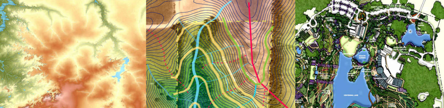
Image credits: [1] QGIS, [2] OSE, [3]
The Open Source Mapping and Site Design workshop is an immersion 5 day experience in farm and landscape planning and design. We will go through a complete process of generating a site plan an map – geared especially at regenerative land use. The course is a beginner’s level crash course in state of art tools for landscape planning and design. Participants will learn basic competence in open source Geographical Information Systems (GIS) software, open source aerial drone mapping, surveying, geolocating, data collection, planting design, and site design. These tools will be used to create a working plan for Factor e Farm – Open Source Ecology’s main development site. Students will gain hands-on experience in accessing existing datasets, collecting site data, taking aerial photos with aerial drones, converting such records into open source GIS map layers, and interpreting both the natural land features and virtual maps for long-term site planning. The tangible outcome are a baseline composite map, and an initial master plan for plantings, earthworks, ponds, and the built environment – as influenced by the nature of the site. The design framework will be based around principles of landscape architecture, Yeoman’s Scale of Permanence, keyline design, and regenerative agriculture. The outcome for participants is gaining the knowledge for replicating the entire process on their own land using open source tools and open access data.
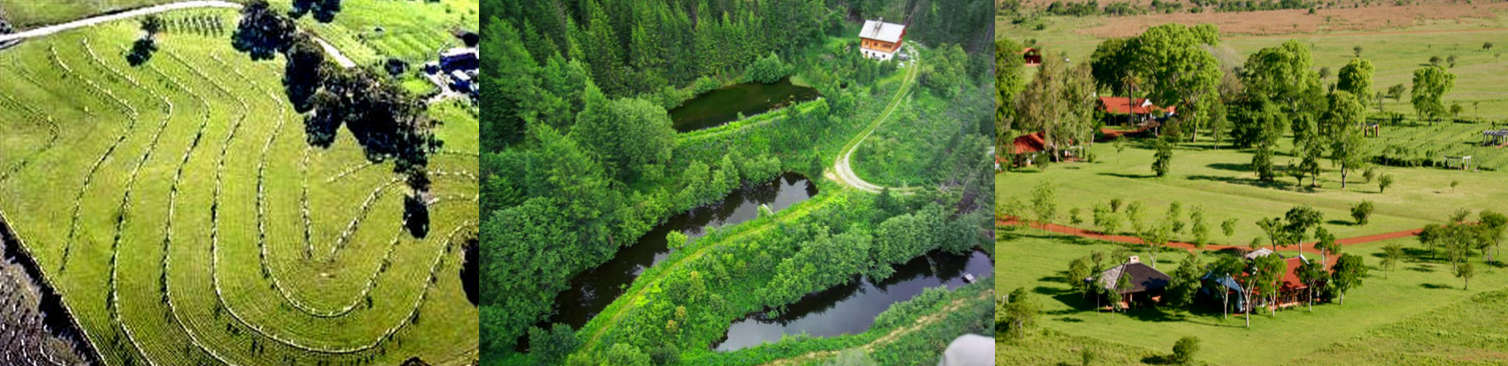
Image credits: [1] Darren J. Doherty, ‘TC5 Agroforestry at Dalpura Farm’, www.Regrarians.org, 2006; [2], [3].
Participants will have a chance to participate in both fieldwork and classroom activity. Fieldwork includes collaborative mapping of topsoil thickness, soil infiltration, and soil composition; taking aerial drone photographs; and mapping key site features. Classroom activity includes importing existing data sets, importing field data, and referencing aerial images within the GIS software. By analyzing elevation maps, students will map drainage patterns to determine locations of ponds, access roads, berms, plantings, and other features. The group will synthesize all available data in a design charette to formulate a facility master plan based on the long-term requirements of the site.
The intent of the workshop is to demystify technologies related to land stewardship – and place powerful tools in the hands of land use planners, farmers, and other land stewards. The goal is to use free and open source tools that anyone can use. To develop a culture of citizen science for the common good – we are developing and documenting state of art tools and techniques.
This workshop is a collaboration between two open source projects – Open Source Ecology and Spatial Ecology. The workshop is intended to begin the process of developing Spatial Ecology’s applications to open source farm design, using open source, state -of-art Geographical Information Systems (GIS) software. We are intending to develop an open source farm design plugin for GIS.
Workshop immersion involves concept and practice. Participants become familiar with one aspect of OSE’s design process, which is related to building the Global Village Construction Set.
The workshop focuses on open source tools and open collaboration, and how such a paradigm can be carried into other areas of human endeavor. This workshop is useful to people interested in learning more about collaborative literacy. The course includes theory but is high on immersion, hands-on skills training and practical results. This immersion course may be especially useful to people who are interested in regenerating degraded landscapes – mainly by retaining water, by building soils, and by perennial crop plantings.
We are inviting those individuals who are interested in learning a basic functional knowledge of GIS and applying the techniques learned to generating a site plan of their own. Further, OSE’s goal is to create open, collaborative ecosystems where we use, improve and document the techniques learned – to achieve greater impact. To facilitate learning and documentation – we are also inviting dedicated documenters and videographers. We also encourage participation by those who find the subject important, and who would consider teaching such design skills in the future. This is consistent with OSE’s mission to create the culture of collaborative citizen participation and stewardship – by training the teachers.
The overall workshop is designed for people interested in transitioning from Zero to Steward of the land. We encourage both novices and those with experience to participate – as those with experience will also learn a number of skills. This course assumes no prior GIS knowledge, though curiosity and eagerness to learn are critical. Participants will practice using a live CD with all the open source software ready to go, and need to bring their own laptops. There are two tracks:
- 5 Day Workshop Participation (July 18-22):
- Documentation Track (July 18-22): Document for access and replicability.
As a bonus, we are also screening a pre-release of a documentary film on one of OSE’s collaborations around the open source tractor and urban agriculture – Reversing the Mississippi.
Have questions? Drop us an email: info at opensourceecology dot org
Instructors

- Stefano Casalegno, Ph.D., is a data scientist, ecologist and an Associate Research Fellow at the University of Exeter in the UK. Trained at plant science, satellite image analyses and spatial ecology, his interests include open source software, ecosystems functioning, and climate change mitigation. He is the co-founder of Spatial Ecology – a training program in spatio-temporal analysis and data processing using open source software and Geographical Information Systems (GIS). Stefano is bringing his experience in ecology, hydrological-climatic modelling and open source GIS to this workshop, with an intent of expanding the Spatial Ecology program to farm design, permaculture, and regenerative agriculture.
- Marcin Jakubowski was trained as a fusion physicist. He left academia right after finishing his Ph.D. to start a farm – in Missouri. For the last 7 years, he has been working on the Global Village Construction Set – a set of enabling tools and machines for building regenerative infrastructures. Marcin is passionate about creating the Open Source Economy – a new operating system for Earth. See Marcin’s bio.
We will have a featured appearance of Darren Doherty via remote teleconference to cover the core elements of regenerative agriculture and site design:
- Darren Doherty has extensive experience across the world in regenerative agriculture project design, development, management and training. A career-long focus on the retrofit of broadacre landscapes has seen Darren acclaimed as a pioneer in this important and often overlooked field. Darren has been involved in the design & development of nearly 2000, mostly broadacre projects across 6 continents in close to 50 countries. Darren is the originator of the Regrarians Platform process which outlines a strategic & logical process to the development of regenerative agricultural systems, and is the program extensively outlined in his new book, the Regrarians Handbook.
Site Planning and Analysis
- Using open source drones for capturing site images
- Analyzing topography for erosion and runoff
- Understanding requirements for the built environment
- Collecting data samples of site and soil properties (drainage, biomass, physical properties)
- Designing earthworks, waterworks, and access roads
- Surveying, geolocating, and referencing points
- Collecting weather data and analyzing microclimates
GIS Software
- Introduction to GrassGIS and QGIS
- Finding and importing existing datasets
- Importing real data and aerial images into GIS with proper referencing
- Using GIS software to calculate runoff and waterways
- Designing plantings in GIS software
- Translating from GIS maps to real points on the land, and vice-versa
- Using GIS to document trees and plantings
- Mapping farm soil properties (ex.: texture, carbon content, soil water retention capacity)
Design Principles – Site Planning
- Basics of Site Planning
- Basics of Landscape Architecture
- Yeoman’s Scale of Permanence
- Water and Erosion Calculations
- Keyline design and earthworks
- Planting design
- Layers of a Baseline Composite Map
Open Collaboration
(we will touch on the basics of OSE’s collaborative design practices to foster open collaboration beyond this workshop)
- Basics of Collaborative Literacy
- Documentation using real-time video uploads, pictures, and social media
- Data collection and importing into GIS
- Using GIS to generate collaborative maps
- Involving the aerial drone community in collaborative mapping
- Creating collaborative, online databases with GIS
Note: schedule is being refined and may change slightly.
Day 1 – Introduction
Morning
- OSE Introduction
- OSE Vision
- Site Tour
- OSE Site Design Vision
- Spatial Ecology introduction and OSGeoLive
- Linux environment – OSGeoLive. Runs in Virtual Machine. Virtualbox.
- Any issues for install? Guide people before the workshop. 20-30GB of space.
- Intro to GIS and Qgis
- OSE Site Planning Tutorial
- Plugins in Qgis
Afternoon
- GIS Planning Usage exercise – getting everything running
- Raster vector data format and manipulation
- Data filtering and harmonization (projections, clipping, mask).
- Map editing
- GRASS functions in QGIS
- QGIS cloud
- Site Planning 101
- Landscape Architecture 101
- Intro to Regenerative Agriculture and Keyline Design
Day 2 – Gathering Data for a Site Plan
Morning
- Online data acquisition: Remote Sensing Data + Open Access Data Repositories
- Lidar Digital Elevation Models (DEMs)
- Climatic data resources
- Open street map and other auxiliary data
- Geology, soil maps / landcover, vegetation maps
- Usage exercise – importing a data set
Afternoon
- Field Data Collection
- GPS – Field data collection
- Capturing and using drone aerial images
- Sample in the field / upload data into GIS
- Tree Mapping
- Topsoil cover, soil permeability, soil structure data collection
- Usage exercise – collation of data and input
- From Collected Data to a Site Plan
- Baseline Composite Layers Map
- Data overlay, map creation, simple queries
- From input data to decision making and site planning
Day 3 – Modeling Site Features
Morning: Tools
- BASIC GIS for site planning – extract knowledge from geo-data to deliver actionable results
- DATA MODELING – process data to acquire key layers
- Raster to vector conversion and data manipulation
- Digital Elevation Model data processing
- Contour Maps: From elevations to contours
- Slope and slope direction maps
- Ponds & Streams: Hydrological modeling
- Soil erosion risk
Afternoon: Applications
- Earthworks – Permaculture Design
- Using GIS to make a plan for Retaining all Moisture on Site
- Using personal weather station and soil properties data
- Topography->Slope
- Surface water->Water accumulation for water catchment ponds
- Subsurface water
- Using GIS to make a plan for Retaining all Moisture on Site
- My Topsoil Carbon Mapping
- Using field data on soils (GPS / organic matter) to generate carbon fertility maps
- Creating gradient maps
- Point – surface interpolation methods (splines/ modeling algorithm)
- Application to soil fertility, soil structure, and soil permeability
Evening – Movie Night
Day 4 – Site Planning: Earthworks, Waterworks, Access, Plantings, Buildings
Morning
- FARM MONITORING – Climate data / microclimate modeling (TO BE CONFIRMED)
- Point to surface methods for microclimate mapping
- Minimum/maximum temperatures for frost risk mapping, heat zones, potential evapotranspiration
- Wind maps
- Laying out Keyline Plowing Plan, Treelines, Pastures, Irrigation Tubing, Ponds, Berms, other Earthworks
Afternoon
- FARM PLANNING – LANDSCAPE MODELLING
- Data model integration
- Scenario maps – Contour Planting – creating planting patterns
- Animated time series and 3d Modeling
- Farm Design Mini Charette
- Criteria Setting for FeF Long Term Vision
Day 5 – The Plan
Morning – Integrate the Plan
- Developing the plan
- Finalize Plan
- Map generation and printout
- Generate different plan scenarios – 4-5 people per working group
Afternoon – Presentations and Discussion
- Laying out Keyline Plowing Plan, Treelines, Pastures, Waterworks, and Earthworks
- Integrate best ideas from different plans
- Discussion and Future Developments
- Share data and experience
- Exchange / Generate Ideas
- Future developments: Open Drone Mapping for 3D contours, open source nursery, IoT monitoring tools
Registration Fee for 5-day Workshop: $750
Registration Fee for Documentation Track (5 days): $400
Sponsor another participant: Sponsor $750 to fund attendance of someone who is on the waiting list for financial assistance.
Discounts for Students and Full Time Farmers: If you are a student or a full time farmer, your cost is 50% off for any of the options. If this is still beyond your means, we can consider Work Exchange, where you stay an extra day to help with site preparation and cleanup. You pay a deep discounted rate. Email us for details.
2-for-1 Discounts: Bring a family member or friend with you for free.
Group Rate: If you can bring a group of 3 or more people including you – we can give you a discount.
True Fans of OSE: As supporting members of OSE, True Fans receive a 25% discount on all of our workshops – on top of the discounts above. You can sign up as a True Fan now to become eligible for the True Fans discount on future workshops.
Donate to OSE: We are a nonprofit organization with 501(c)3 status. You can make tax-deductible contributions to us.
Workshop fee includes workshop tuition. We can pick you up from the airport, Kansas City International (about an hour away). Participants may secure a hotel in Cameron, Missouri, (15 miles away). Participants are also welcome to camp at Factor e Farm. We have a camping location which includes a composting toilet. Showers and a bathroom are located in our main house, HabLab. Meals will be done as a combination of catered dinner and potluck lunch. For lunch – bring your own or bring some to share. OSE will provide continental breakfast and make-your-own sandwiches for lunch. A kitchen is available for basic food preparation. We also have a swimming pool that is open during daylight hours for relaxation.
Payment Options: PayPal, Credit Card, Dwolla, Bitcoin, Check, Money Order, or Cash
Registration for the choices above is found on Eventbrite, but Eventbrite accepts only PayPal or Credit Card. If you would like to pay by other means you can select that option at Eventbrite, but then you have to submit your payment independently of Eventbrite. We accept Dwolla, Bitcoin, Check, Money Order, or Cash. Your registration will be confirmed upon receipt of payment. Please make checks payable to Open Source Ecology. Our mailing address is OSE, 909 SW Willow Rd, Maysville, MO 64469. For mailings, please write “Gasifier Workshop” along with number of days on your instrument of payment.
Cancellation Policy
If for any reason you can’t attend a workshop you registered for we will be happy to (a) transfer you credit towards another Gasifier workshop in the future; (b) or equivalent credit towards any other other OSE workshop; (c) substitute the name on your ticket and have a friend take your place.
Pay with Dwolla
Dwolla charges lower transaction costs than PayPal. If you are paying by Dwolla, register at Eventbrite and select the Dwolla option, then pay independently via Dwolla (Dwolla is not currently integrated into Eventbrite). Use Open Source Ecology or ops@opensourceecology.org as the Dwolla recipient.
Pay with Bitcoin
Bitcoin is a decentralized payment system. You can pay via bitcoin for your particular choice via a bitcoin amount translated by the current bitcoin exchange rate on the day that you register. OSE’s Bitcoin Address is 166yC48RakrZdtsBj36vY9q29CpzknHbxY
Pay with Paypal / Credit Card
To pay with paypal/credit card, please use the the Eventbrite form below. Eventbrite charges a 6% fee on top of the ticket price.

when will you do this course again?
This looks truly amazing and I would have been all over this had it not been scheduled during the ESRI GIS conference that I am required to go to for work. I hope this is offered again in the future.
Hi im from Uruguay south america! I’m interested in this full course but I can only pay half of it, I’m a farmer but I can stay one day of working there. Can you help me with this? Also I don’t have where to stay do you have tents or anywhere I can stay? I need you to contact me as soon as possible because I have to purchase a flight for this and arrange everything in my stay, food and all of this.. When the course is finished do you give some sort of title? Thanks and hope to hear from you soon!
Re: your group rate. Does that mean I can bring 4 or 5 or more people & it will be $1500?